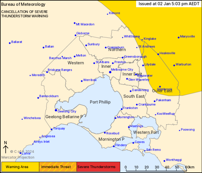
5:03pm: Severe thunderstorms are no longer affecting the Melbourne Area. The immediate threat of severe thunderstorms for Melbourne has passed. The BoM is monitoring the situation. Further detailed warnings will be issued as necessary.
4:42pm: Severe thunderstorms in the Melbourne area have temporarily eased. The redevelopment of severe thunderstorms remains possible. The BoM is monitoring the situation. Further detailed warnings will be issued as necessary.
4:20pm: Storm now forecast to affect Croydon, Mt Dandenong and Ringwood by 4:50 pm and Belgrave, Scoresby and the area south of Belgrave by 5:20pm.
A more general severe thunderstorm warning is current for the Northern Country, North Central and parts of the Central, Mallee, North East and West and South Gippsland forecast districts.
Local weather, besides BoM stations, can be found by visiting APRS.
4pm: Damaging winds detected near Greensborough and Hurstbridge. Thunderstorm moving easterly, towards Gippsland. Forecasted to affect Lilydale, Yarra Glen and the area south of Kinglake by 4:30pm and Healesville, Yarra Junction and the area east of Lilydale by 5:00pm.
3:30pm: Flash flooding was detected by the BoM near Broadmeadows and Craigieburn. These thunderstorms are moving towards the east to southeast. They are forecast to affect Greensborough, Hurstbridge and Whittlesea by 4:00pm and Kangaroo Ground, Yarra Glen and the area south of Kinglake by 4:30pm.
Severe lightning is also occurring in and nearby to the affected areas. Gippsland and eastern Victoria is expected to be affected later this afternoon or early this evening as the storm cell moves east.
3:08pm: The Bureau of Meteorology warns that, at 3:10pm, a severe thunderstorm likely to produce heavy rainfall that may lead to flash flooding was detected near Craigieburn and Sydenham.
This thunderstorm is moving towards the east. It is forecast to affect Keilor and Melbourne Airport by 3:25 pm and Broadmeadows, Essendon and Whittlesea by 3:40pm.
The State Emergency Service advises that people should:
* If driving conditions are dangerous, safely pull over away from trees, drains, low-lying areas and floodwater. Avoid travel if possible.
* Stay safe by avoiding dangerous hazards, such as floodwater, mud, debris, damaged roads and fallen trees.
* Be aware – heat, fire or recent storms may make trees unstable and more likely to fall when it’s windy or wet.
* Check that loose items, such as outdoor settings, umbrellas and trampolines are safely secured. Move vehicles under cover or away from trees.
* Stay indoors and away from windows.
* If outdoors, move to a safe place indoors. Stay away from trees, drains, gutters, creeks and waterways.
* Stay away from fallen powerlines – always assume they are live.
* Stay informed: Monitor weather warnings, forecasts and river levels at the Bureau of Meteorology website, and warnings through VicEmergency website/app/hotline.
The next warning is due to be issued by 3:40pm.
A more general severe thunderstorm warning is also current for parts of the Central, Mallee, Northern Country, North Central and Wimmera districts.
Warnings are also available through TV and radio broadcasts, the Bureau’s website at www.bom.gov.au or call 1300 659 210.

